


Dave Catts
Current Gallery: eastcoast ( piece)
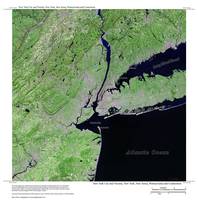
Images of the East Coast of the United States: birds-eye views of familiar places, cruising grounds, ports-of-call, boating, hiking and fishing spots: geography, places to visit and recreate. The map titles are from a central physiographic feature and contain over-edge. All images are vertical views (planimetric) of 3D environmental models, and the image corners are specific geographic coordinates (georectified). These images are 10,000-pixels in the longest dimension; so they can accomodate the "Massive" print size at Imagekind. For Gulf Coast locations, see the "gulfcoast" Gallery; and the Florida Keys is in the Island Gallery.
Images of the East Coast of the United States: birds-eye views of familiar places, cruising grounds, ports-of-call, boating, hiking and fishing spots: geography, places to visit and recreate. The map titles are from a central physiographic feature and contain over-edge. All images are vertical views (planimetric) of 3D environmental models, and the image corners are specific geographic coordinates (georectified). These images are 10,000-pixels in the longest dimension; so they can accomodate the "Massive" print size at Imagekind. For Gulf Coast locations, see the "gulfcoast" Gallery; and the Florida Keys is in the Island Gallery.
Gallery-quality prints · Independent artists · Décor to adore


from $ 12


from $ 12

from $ 12


from $ 12


from $ 12


from $ 12


from $ 12


from $ 12


from $ 12


from $ 12